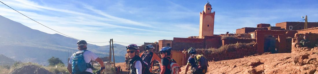
MOROCCO
Morocco (/məˈrɒkoʊ/ (About this soundlisten); Arabic: المغرب, romanized: al-maḡrib, lit. 'place the sun sets; the west'; Standard Moroccan Tamazight: ⵍⵎⵖⵔⵉⴱ, romanized: lmeɣrib), officially the Kingdom of Morocco (Arabic: المملكة المغربية, romanized: al-mamlaka al-maḡribiyya, lit. 'The Western Kingdom'; Standard Moroccan Tamazight: ⵜⴰⴳⵍⴷⵉⵜ ⵏ ⵍⵎⵖⵔⵉⴱ, romanized: tageldit n lmaɣrib), is a country located in the Maghreb region of North Africa. It overlooks the Mediterranean Sea to the north and the Atlantic Ocean to the west, with land borders with Algeria to the east and Western Sahara (status disputed) to the south. Morocco also claims the exclaves of Ceuta, Melilla and Peñón de Vélez de la Gomera, all of them under Spanish jurisdiction, as well as several small Spanish-controlled islands off its coast.The capital is Rabat and the largest city is Casablanca.Morocco spans an area of 710,850 km2 (274,460 sq mi) and has a population of over 36 million.
Since the foundation of the first Moroccan state by Idris I in 788 AD, the country has been ruled by a series of independent dynasties, reaching its zenith under Almoravid and Almohad rule, when it spanned parts of Iberia and northwestern Africa. The Portuguese Empire began in Morocco in the 15th century, following Portuguese conquests along the Moroccan coast, founding settlements which lasted into the 17th and 18th centuries. The Marinid and Saadi dynasties resisted foreign domination into the 17th century, allowing Morocco to remain the only northwest African country to avoid Ottoman occupation. The Alaouite dynasty, which rules to this day, seized power in 1631. The country's strategic location near the mouth of the Mediterranean attracted the interest of Europe, and in 1912, Morocco was divided into French and Spanish protectorates, with an international zone in Tangier. It regained its independence in 1956, and has since remained comparatively stable and prosperous by regional standards, with the fifth largest economy in Africa.
Morocco claims the non-self-governing territory of Western Sahara, formerly Spanish Sahara, as its Southern Provinces. After Spain agreed to decolonise the territory to Morocco and Mauritania in 1975, a guerrilla war arose with local forces. Mauritania relinquished its claim in 1979, and the war lasted until a ceasefire in 1991. Morocco currently occupies two thirds of the territory, and peace processes have thus far failed to break the political deadlock.
The sovereign state is a unitary Semi-constitutional monarchy with an elected parliament. The country wields significant influence in both Africa and the Arab world, and is considered a regional power and a middle power. The King of Morocco holds vast executive and legislative powers, especially over the military, foreign policy and religious affairs. Executive power is exercised by the government, while legislative power is vested in both the government and the two chambers of parliament, the Assembly of Representatives and the Assembly of Councillors. The king can issue decrees called dahirs, which have the force of law. He can also dissolve the parliament after consulting the Prime Minister and the president of the constitutional court.
Morocco's predominant religion is Islam, and its official languages are Arabic and Berber, the latter achieving official recognition in 2011, having been the native language of Morocco before the Muslim conquest in the seventh century C.E. The Moroccan dialect of Arabic, referred to as Darija, and French are also widely spoken. Moroccan culture is a blend of Berber, Arab, Sephardi Jews, West African and European influences.
Morocco is a member of the Arab League, the Union for the Mediterranean and the African Union
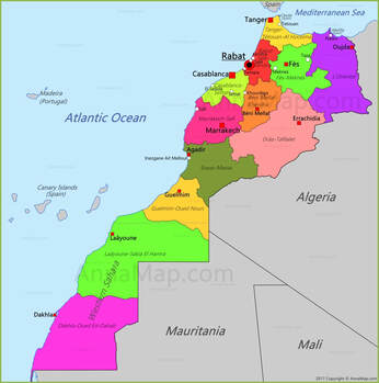
Regions of Morocco:
On 3 January 2010, the Moroccan government established the Consultative Commission for the Regionalization (CCR), which aimed to decentralize power to the regions, and confer a greater autonomy to the regions coinciding with the Western Sahara. The commission published provisional names and numbers for the new regions, and their names were officially fixed in the Bulletin Officiel dated 5 March 2015. The new regional councils elected their presidents on 14 September 2015 and regional governors were appointed on 13 October 2015
|
Regions are currently the highest administrative divisions in Morocco. Since 2015, Morocco officially administers 12 regions, including one (Dakhla-Oued Ed-Dahab) that lies completely within the disputed territory of Western Sahara and two (Laâyoune-Sakia El Hamra and Guelmim-Oued Noun) that lie partially within it. The regions are subdivided into a total of 75 second-order administrative divisions, which are prefectures and provinces.
A region is governed by a directly elected regional council. The president of the council is responsible for carrying out the council's decisions. Prior to the 2011 constitutional reforms, this was the responsibility of the Wali, the representative of the central government appointed by the King, who now plays a supporting role in the administration of the region. |
|
Dakhla-Oued Ed-Dahab :
The region comprises two provinces:
• Aousserd Province Aousserd is a province in the Moroccan economic region of Dakhla-Oued Ed-Dahab, and the disputed territory of Western Sahara. At the 2004 Census it had a population of 7,689. • Oued Ed-Dahab Province Oued Ed-Dahab is a province in the Moroccan economic region of Dakhla-Oued Ed-Dahab, in the disputed territory of Western Sahara. Its population at the 2004 Census was 65,378. Its major town is Dakhla. |
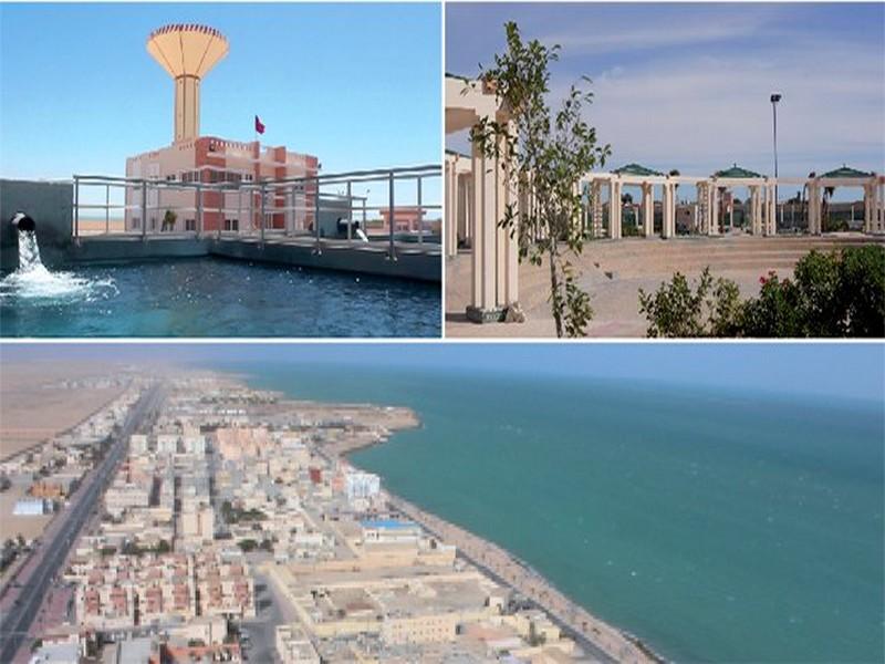
Dakhla-Oued Ed-Dahab (Arabic: الداخلة - وادي الذهب, romanized: ad-dāḵla - wādī ḏ-ḏahab; Berber languages: ⴷⴷⴰⵅⵍⴰ ⴰⵙⵉⴼ ⵏ ⵡⵓⵕⵖ, romanized: ddaxla asif n wuṛɣ) is one of the twelve regions of Morocco. Before September 2015 it was known as Oued Ed-Dahab-Lagouira (Arabic: وادي الذهب لكويرة). It is situated in the disputed territory of Western Sahara, considered by Morocco to be the southern part of the country. The Polisario Front and other independence-seeking Sahrawis consider this to be a part of the Sahrawi Arab Democratic Republic. The United Nations and most countries do not recognize either Moroccan sovereignty over the area, or the self-declared Sahrawi republic. The region covers an area of 50,880 km² and had a population of 142,955 according to the 2014 census. The capital is the coastal city of Dakhla, formerly known as Villa Cisneros. 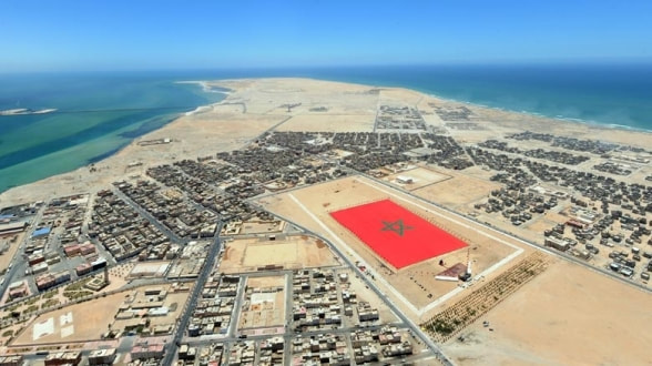
|
Laâyoune-Sakia El Hamra
|
Laâyoune-Sakia El Hamra (Arabic: العيون - الساقية الحمراء, romanized: al-ʿuyūn as-sāqiya l-ḥamrāʾ; Berber languages: ⵍⵄⵢⵓⵏ ⵜⴰⵔⴳⴰ ⵜⴰⵣⴳⴳⵯⴰⵖⵜ, romanized: lɛyun targa tazggʷaɣt) is one of the twelve regions of Morocco. It is mainly located in the disputed territory of Western Sahara: the western part of the region is administered by Morocco and the eastern part by the Sahrawi Arab Democratic Republic. The region as claimed by Morocco covers an area of 140,018 square kilometres (54,061 sq mi) and had a population of 367,758 as of the 2014 Moroccan census. The capital of the region is Laâyoune.
|
Guelmim-Oued Noun
|
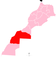
Guelmim-Oued Noun (Arabic: كلميم-وادي نون, romanized: gulmīm wādī nūn; Berber languages: ⴳⵓⵍⵎⵉⵎ ⴰⵙⵉⴼ ⵏⵓⵏ, romanized: gulmim asif nun) is one of the twelve regions of Morocco. The southeastern part of the region is located in the disputed territory of Western Sahara and a small strip of land in this area is administered by the Sahrawi Arab Democratic Republic. The region as a whole covers an area of 46,108 km2 and had a population of 433,757 as of the 2014 Moroccan census. The capital of the region is Guelmim.
|
|
Souss-Massa
|
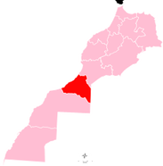
Souss-Massa (Arabic: سوس ماسة, romanized: sūs māssa; Berber languages: ⵙⵓⵙ ⵎⴰⵙⵙⴰ, romanized: sus massa) is one of the twelve regions of Morocco. It covers an area of 51,642 km² and had a population of 2,676,847 as of the 2014 Moroccan census. The capital of the region is Agadir.
Souss-Massa borders the regions of Marrakesh-Safi to the north, Drâa-Tafilalet to the northeast and Guelmim-Oued Noun to the southwest. To the southeast is Algeria's Tindouf Province. The region faces the Atlantic Ocean on its western side: much of the coast is protected by Souss-Massa National Park. |
Drâa-Tafilalet
|
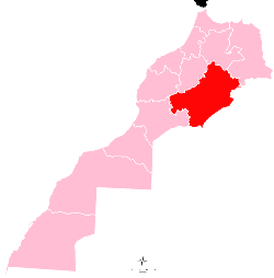
Drâa-Tafilalet (Arabic: درعة - تافيلالت, romanized: darʿa - tāfīlālt; Berber languages: ⴷⵔⵄⴰ ⵜⴰⴼⵉⵍⴰⵍⵜ, romanized: drɛa tafilalt) is one of the twelve regions of Morocco. It covers an area of 88,836 km2 and had a population of 1,635,008 as of the 2014 Moroccan census. The capital of the region is Errachidia.
Drâa-Tafilalet is situated in the Atlas Mountains of Morocco. Its main watersheds are that of the Draa River in the west and the Ziz River, which irrigates the Tafilalt oasis, in the east. Drâa-Tafilalet borders five other Moroccan regions: Souss-Massa to the southwest, Marrakech-Safi to the west, Béni Mellal-Khénifra to the northwest, Fès-Meknès to the north, and Oriental to the northeast. It also borders two of Algeria's provinces, Tindouf in the south and Béchar in the southeast. |
|
Marrakesh-Safi
|
Marrakesh-Safi (Arabic: مراكش آسفي, romanized: murrākuš āsafi; (Berber languages: ⵎⵕⵕⴰⴽⵛ ⴰⵙⴼⵉ, romanized: mṙṙakš asfi) is one of the twelve regions of Morocco. Its population in 2014 was 4,520,569. The capital is Marrakesh.
Marrakesh-Safi was formed in September 2015 by merging the old region of Marrakesh-Tensift-El Haouz with the provinces of Safi and Youssoufia in Doukkala-Abda region. |
Casablanca-Settat
|
Casablanca-Settat (Arabic: الدار البيضاء - سطات, romanized: ad-dār al-bayḍāʾ - siṭṭāt; Berber languages: ⴰⵏⴼⴰ - ⵙⵟⵟⴰⵜ, romanized: anfa - sṭṭat) is one of the twelve administrative regions of Morocco. It covers an area of 20,166 km² and recorded a population of 6,861,739 in the 2014 Moroccan census, 69% of which lived in urban areas. The capital of the region is Casablanca.
Casablanca-Settat is located on the Atlantic coast. It borders the regions of Rabat-Salé-Kénitra to the northeast, Béni Mellal-Khénifra to the southeast, and Marrakesh-Safi to the south. Part of the border with Marrakesh-Safi follows the course of the Oum Er-Rbia River, which flows northwest and empties into the Atlantic at Azemmour. The river divides the region into two plains, the Doukkala in the west and the Chaouia in the east. Several reservoirs provide water for the region, including that of the Al Massira Dam on the Oum Er-Rbia and one on the Oued Mellah south of Mohammedia. |
|
Béni Mellal-Khénifra
|
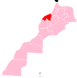
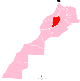
Béni Mellal-Khénifra (Arabic: بني ملال - خنيفرة, romanized: banī mallāl - ḵunayfira; Berber languages: ⴰⵢⵜ ⵎⵍⵍⴰⵍ - ⵅⵏⵉⴼⵕⴰ, romanized: ayt mllal - xnifṛa) is one of the twelve regions of Morocco. It covers an area of 28,374 km2 and recorded a population of 2,520,776 in the 2014 Moroccan census. The capital of the region is Beni Mellal.
Béni Mellal-Khénifra is located in the interior of the country. It borders Rabat-Salé-Kénitra to the north, Fès-Meknès to the northeast, Drâa-Tafilalet to the southeast, Marrakesh-Safi to the southwest and Casablanca-Settat to the northeast. In the western and central part of the region is the productive Tadla plain irrigated by the Oum Er-Rbia River. This plain is bracketed by the High Atlas mountains which run through the southern and eastern parts of the region, and the foothills of the Middle Atlas to the north. |
Rabat-Salé-Kénitra
|
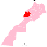
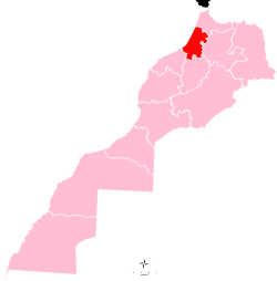
Rabat-Salé-Kenitra (Arabic: الرباط-سلا-القنيطرة, romanized: ar-ribāṭ salā al-qunayṭira; Berber languages: ⴻⵕⵕⴱⴰⵟ-ⵙⵍⴰ-ⵇⵏⵉⵟⵔⴰ, romanized: eṛṛbaṭ sla qniṭra) is one of the twelve administrative regions of Morocco. It is situated in north-western Morocco and has a population of 4,580,866 (2014 census). The capital is Rabat. Rabat-Salé-Kenitra was formed in September 2015 by merging Rabat-Salé-Zemmour-Zaer with the region of Gharb-Chrarda-Béni Hssen
|
|
Fès-Meknès
|
Fez-Meknes (Arabic: فاس-مكناس, romanized: fās maknās; Berber languages: ⴼⴰⵙ-ⵎⴽⵏⴰⵙ, romanized: fas mknas) is among the twelve Regions of Morocco. It has a population of 4,236,892 (2014 census).[1] Its capital is Fez.[2] Its current president is Mohand Laenser, and its current wali is Said Zniber. Fès-Meknes was formed in September 2015 by merging Fès-Boulemane with the prefecture of Meknès and the provinces of El Hajeb and Ifrane (in Meknès-Tafilalet region) and the provinces of Taounate and Taza (in Taza-Al Hoceima-Taounate region).
|
Oriental (Morocco)
|
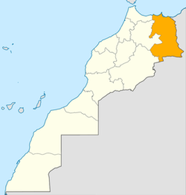
Oriental (Arabic: الشرق, romanized: aš-šarq; Berber languages: ⵜⴰⴳⵎⵓⴹⴰⵏⵜ, romanized: tagmuḍant) is one of the twelve regions of Morocco, located in the eastern part of the country. It covers an area of 90,127 km² and has a population of 2,314,346 (2014 census).
The capital and the largest city is Oujda, and the second largest city is Nador. The region includes 7 provinces and one prefecture. Mohamed Mhidia became wali (governor) of the region in 2015. A majority of the population of Oriental speak Moroccan Arabic (86.2%) as a first or second language. A large minority speak the Rif-Berber language (38.4%) as a first language. Small numbers speak Eastern Middle Atlas Tamazight and Figuig Tamazight, principally in the south of Oriental. |
|
Tanger-Tetouan-Al Hoceima
|
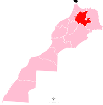
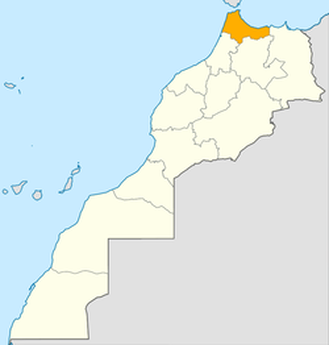
Tanger-Tetouan-Al Hoceima (Arabic: طنجة - تطوان - الحسيمة, romanized: ṭanja - tiṭwān - al-ḥusayma; Berber languages: ⵟⴰⵏⵊⴰ ⵜⵉⵟⴰⵡⵉⵏ ⵍⵃⵓⵙⵉⵎⴰ, romanized: ṭanja tiṭawin lḥusima) is one of the twelve regions of Morocco. It covers an area of 15,090 km² and recorded a population of 3,556,729 in the 2014 Moroccan census. The capital of the region is Tangier. Tanger-Tetouan-Al Hoceima is the northernmost of Morocco's twelve regions. In the north it faces the Strait of Gibraltar and the Mediterranean Sea and borders the Spanish exclave of Ceuta. It also borders the Moroccan regions of Rabat-Salé-Kénitra to the southwest, Fès-Meknès to the southeast and Oriental to the east. The Rif rises in the eastern part of the region and is the location of Al Hoceima National Park and Talassemtane National Park. The land near the Atlantic coast in the west is less rugged, and the fertile southwestern corner of the region is drained by the Loukkos River.
|